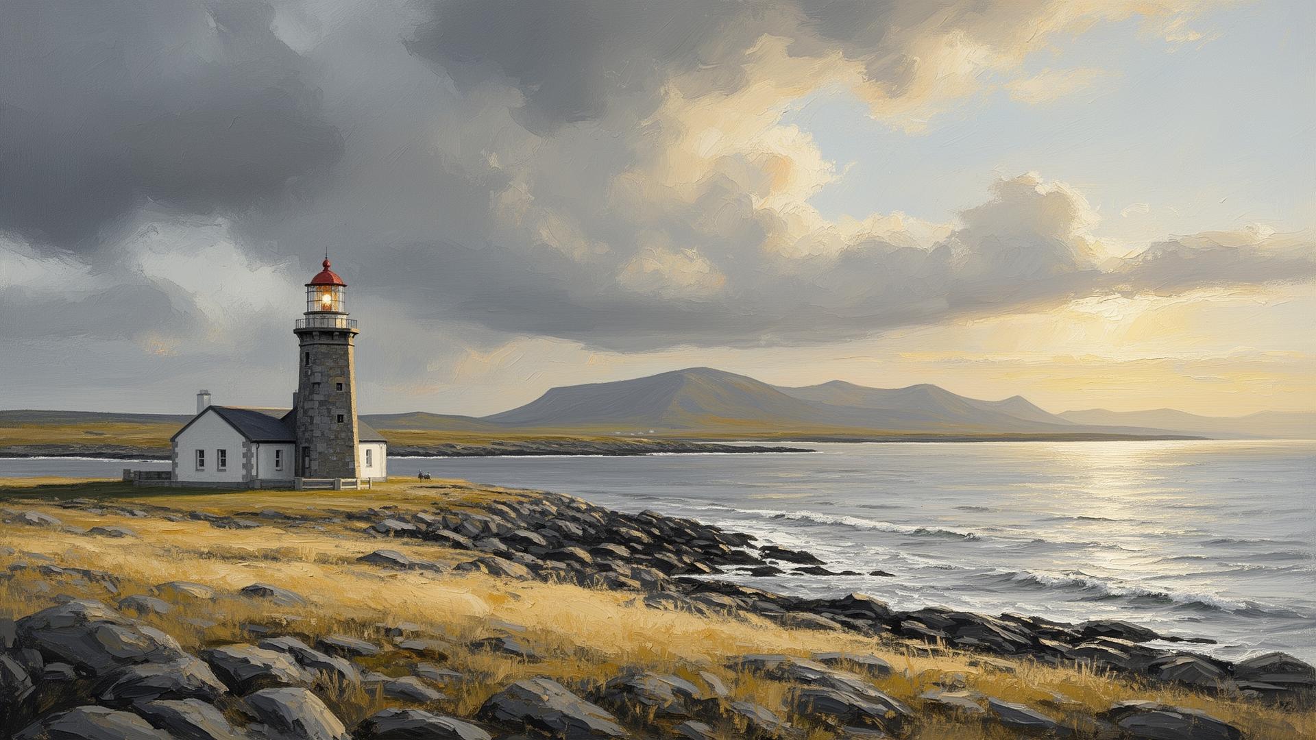
The Atlantic Companion · Wild Atlantic Way · Mayo

Welcome to Mullet Peninsula.
We're glad you're here.

The Mullet — An Muirthead — is a flat, treeless peninsula in the far west of Mayo, joined to the mainland by a thin neck of land at Belmullet town. A Gaeltacht. Beaches everywhere — Mullaghroe, Cross, Elly Bay — and the offshore Inishkea islands, abandoned since 1934. Blacksod Lighthouse on the southern tip received the 1944 weather report from keeper Ted Sweeney that delayed the D-Day landings by 24 hours. The most westerly point of mainland Mayo, and one of the WAW's last truly under-visited stretches.

Belmullet, the long strands, the islands at the end of Mayo.

Sharing from the Wild Atlantic Way

You're in Mullet Peninsula. Send it to someone who'd love it.

First things first

Where are you headed next?

Tell us once and we'll shape the rest of the page around it.

The essentials

What you shouldn't miss.

Locally chosen, not algorithmic. In rough order of "if you only do one thing".

History

Blacksod Lighthouse

A square granite lighthouse built in 1864 on the southern tip of the Mullet. On 3 June 1944, keeper Ted Sweeney's hourly weather report — recording a falling barometer over the North Atlantic — was relayed to General Eisenhower in England. Eisenhower postponed the Normandy landings by 24 hours. A small museum in the keeper's quarters tells that story.

Good to know · Off the R313 at the southern end of the peninsula. Museum seasonal — check ahead.

Island

Inishkea Islands

Two low, flat islands off the western Mullet coast, abandoned in 1934 after a fishing tragedy in which ten young men drowned. The roofless village houses, the Naomh chapel, and a population of barnacle geese in winter. Day boat trips from Blacksod or Belmullet in summer.

Good to know · Boats run on demand from Blacksod and Belmullet — book ahead, weather-dependent. Bring food and water; no facilities on the islands.

Beach

Elly Bay

A long curve of pale Blue Flag sand on the inner shore of the Mullet, sheltered, kid-friendly, water shelving gently. Looks across the bay to Achill in the distance.

Good to know · Free parking. Lifeguards in summer. Toilets and showers in season.

Nature

Erris Head Loop Walk

A 5km waymarked clifftop loop at the northern tip of the Mullet, looking across to Stags of Broadhaven and Eagle Island. Sea cliffs, an EIRE 64 marker (the WWII coastal lookout signs), and on a clear day, all the way back to Donegal.

Good to know · Signposted from the R313. Free, always open. Allow 90 minutes; sturdy shoes.

Town

Belmullet town

The only town on the peninsula — Béal an Mhuirthead, 'mouth of the Mullet,' founded by William Carter in 1825 on the narrow neck of land. Two streets meeting at a square. The 19th-century Carter's Canal cuts through the centre, joining Blacksod Bay to Broad Haven Bay so boats no longer needed to round Erris Head.

Good to know · Free parking around the square. Fuel, supermarket, ATMs all in town.

Beach

Cross Strand and Mullaghroe

Two long Atlantic-facing beaches on the western side of the peninsula. Cross is wide, exposed, often the cleanest break on the west coast for surfers; Mullaghroe is calmer, sandy, with a reef offshore.

Good to know · Free parking at both. No lifeguards. Surf-experienced swimmers only at Cross — strong rip.

Local businesses

Places we'd point a friend to.

Hand-picked, not paid for. The ferries, the beds, the pubs and the bike hire that make a visit work.

Before you go. These listings are compiled from public sources and aren't yet verified by the businesses themselves. Hours, menus and prices change with the seasons — always check directly with the venue before travelling, and book ahead in July and August. Owners can get in touch to update their listing.

Eat

Drink

Stay

Do

Run a place in Mullet Peninsula?

Our directory is curated, not pay-to-play. If we'd recommend you, you can be on here.

See how to get listed

Got a window or a counter?

Download a free A5 QR card for Mullet Peninsula — print it, stick it up, and visitors land straight on the Mullet Peninsula guide.

Ask a local

The bits that aren't on Google.

Common questions

What people ask about Mullet Peninsula.

Where is the Mullet Peninsula?

The Mullet (Iorras) is a long, narrow, almost-island peninsula on the far west coast of County Mayo, joined to the mainland at the town of Belmullet. It's one of the most remote and least-visited stretches of the Wild Atlantic Way, deeply Irish-speaking, with miles of unspoilt sand beaches on the western side facing the open Atlantic.

Is the Mullet Peninsula worth visiting?

Yes if you want one of the wildest, quietest stretches of the entire Wild Atlantic Way. The Mullet has long unspoilt beaches (Cross, Mullaghroe, Annagh), the Blacksod Bay views, the historic Eachléim and the offshore Inishkea Islands. There's almost no tourist infrastructure — that's the appeal and the challenge.

What is there to do on the Mullet Peninsula?

Walk on Cross Beach or Mullaghroe Beach, drive the full length of the peninsula to Blacksod Lighthouse, visit Eachléim and the Ionad Deirbhile Heritage Centre, and consider a boat trip to the now-uninhabited Inishkea Islands. Most visitors do it as a long day-trip from a Ballina or Westport base.

Why is Blacksod Lighthouse famous?

The weather observation at Blacksod Lighthouse on 3 June 1944 was the report that caused the D-Day landings to be postponed by 24 hours, almost certainly saving the operation. The lighthouse and its small museum tell the story; the lighthouse itself sits on a striking pink-granite outcrop at the tip of the Mullet.

Practical

The things you'll wish you'd known.

Fuel
Belmullet only. Fill up before going down to Blacksod or up to Erris Head.
Cash
AIB and Bank of Ireland in Belmullet.
Pharmacy
Belmullet, Mon–Sat. Castlebar for anything urgent.
Parking
Free almost everywhere. Belmullet square is free; pay-and-display has not arrived.
Phone signal
Patchy across the peninsula, weak at Blacksod and Erris Head. Download maps in Belmullet.
An Ghaeltacht
The Mullet is officially Irish-speaking. Most signage is bilingual; some Erris road signs are Irish-only.

Designed & developed by ideapath.app