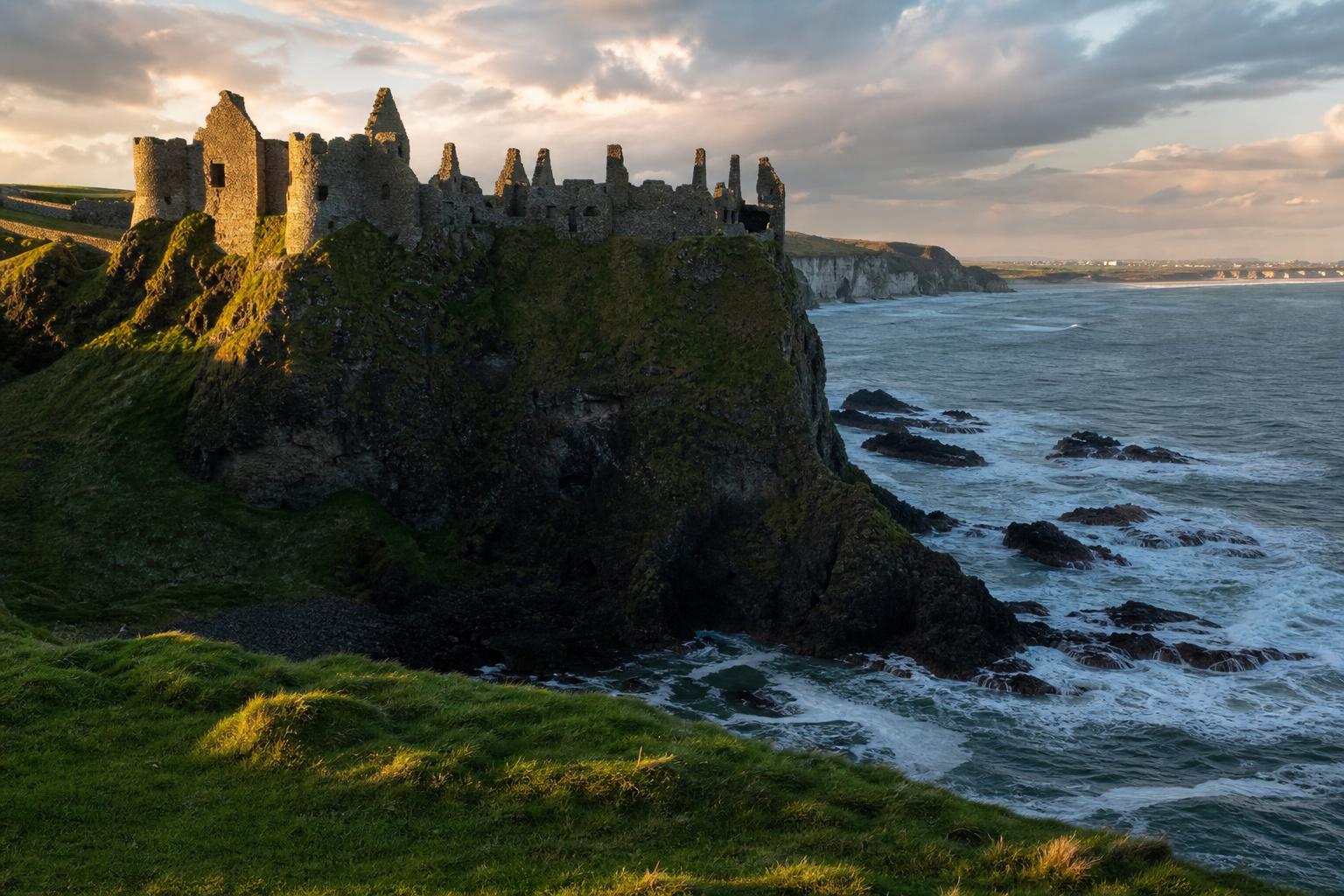
The Atlantic Companion · Causeway Coastal Route · Antrim

Welcome to Dunluce & the Causeway cliffs.
We're glad you're here.

Three miles of basalt cliff between Portrush and the Giant's Causeway, hung with seabirds and crowned by Dunluce Castle — a 13th-century McDonnell stronghold balanced on a stack with the Atlantic eating away below. The kitchen famously slid into the sea in 1639. Most people drive past en route to the Causeway. Stop. The castle is the most photographable ruin in Ireland and the cliff path beyond it is two of the best walking miles on the entire coast.

The ruined castle on the cliff edge, and the coast path to the Causeway.

Sharing from the Wild Atlantic Way

You're in Dunluce & the Causeway cliffs. Send it to someone who'd love it.

First things first

Where are you headed next?

Tell us once and we'll shape the rest of the page around it.

The essentials

What you shouldn't miss.

Locally chosen, not algorithmic. In rough order of "if you only do one thing".

History

Dunluce Castle

A 13th-century Norman castle rebuilt by the McDonnells of Antrim in the 1500s. Sits on a basalt outcrop joined to the mainland by a narrow bridge with a sheer drop on three sides. Inhabited until the kitchen — and the cooks — fell into the sea during a 1639 storm. The lost town of Dunluce, an Elizabethan settlement, is being excavated in the field beside it.

Good to know · Open daily, paid entry. The view from the road is free and arguably better. Car park signposted from the A2.

View

Magheracross viewpoint

A roadside layby on the A2 west of Dunluce, with one of the best long views on the coast — Portrush headland and Inishowen one way, the white cliffs and the Causeway the other. Five minutes; worth the stop every time.

Good to know · Free. Layby on the A2 between Portrush and Dunluce. Easy in and out — popular for sunset.

Beach

Runkerry Strand & the Causeway approach

The mile-long sand crescent west of the Causeway visitor centre, almost always empty even when the Causeway car park is full. Walk in from Bushmills along the riverside path or from the visitor centre by the cliff approach. Runkerry House on the headland was Lord Macnaghten's late-Victorian summer pile.

Good to know · Free. Park at Bushmills riverside and walk (25 min) or at the Causeway visitor centre and approach from the east.

Drive

The Causeway cliff path (west)

The clifftop path running from the Causeway visitor centre back toward Runkerry — three miles of basalt edge, fulmars wheeling below, the headland at Runkerry, then down to the strand. Far quieter than the eastern cliff path everyone walks. Loop back via the road for a 90-minute round.

Good to know · Trailhead at the Causeway visitor centre. Exposed in weather. The Causeway Rambler bus (summer only) loops back if you don't want to walk the road.

Nature

Portcoon and Runkerry caves

Two sea caves cut into the basalt below the cliff path — Portcoon's mouth visible from the path above, Runkerry only properly seen by boat. Aquaholics in Portrush run RIB tours along this stretch in summer that get you under the cliffs and into the cave mouths.

Good to know · Walk-by view from the cliff path. Boat trips from Portrush harbour weather-dependent — book ahead in season.

Local businesses

Places we'd point a friend to.

Hand-picked, not paid for. The ferries, the beds, the pubs and the bike hire that make a visit work.

Before you go. These listings are compiled from public sources and aren't yet verified by the businesses themselves. Hours, menus and prices change with the seasons — always check directly with the venue before travelling, and book ahead in July and August. Owners can get in touch to update their listing.

Do

Run a place in Dunluce & the Causeway cliffs?

Our directory is curated, not pay-to-play. If we'd recommend you, you can be on here.

See how to get listed

Got a window or a counter?

Download a free A5 QR card for Dunluce & the Causeway cliffs — print it, stick it up, and visitors land straight on the Dunluce & the Causeway cliffs guide.

Ask a local

The bits that aren't on Google.

Common questions

What people ask about Dunluce & the Causeway cliffs.

Is Dunluce Castle worth visiting?

Yes — Dunluce is the most dramatically sited castle ruin in Ireland, perched on a cliff edge above the sea between Portrush and the Giant's Causeway. Part of the kitchen famously fell into the sea in 1639. Allow 1 to 1.5 hours including the small visitor centre. The exterior alone is worth a stop even if you don't pay in.

Was Dunluce Castle in Game of Thrones?

Dunluce Castle was used as the exterior of the House of Greyjoy seat at Pyke in Game of Thrones (Season 2 onwards). The site is also well known as the inspiration for the album cover of Led Zeppelin's Houses of the Holy.

How far is Dunluce Castle from the Giant's Causeway?

Dunluce Castle is about 5 km west of the Giant's Causeway on the A2 coastal road, roughly a 7-minute drive. The two sit on the same dramatic stretch of clifftop coast and pair naturally with each other and with Bushmills Distillery for a half-day or full day on the north Antrim coast.

What else is along the Causeway Coast cliffs near Dunluce?

The Causeway Cliffs path runs the whole way from Dunluce through Portballintrae and on to the Giant's Causeway — about 7 km one way, on a mix of clifftop and beach. Magheracross viewpoint, between Portrush and Dunluce, gives the best layered view of the cliffs and the castle together.

Practical

The things you'll wish you'd known.

Fuel
Bushmills (5 min east) or Portrush (5 min west). No filling stations between.
Cash
Cash in Bushmills or Portrush. The castle takes card; the cliff path is free.
Currency
Pound sterling (£).
Parking
Free layby at Magheracross. Paid car park at Dunluce. Causeway visitor centre car park is paid (NT members free).
Phone signal
Patchy below the cliff line. Download maps before walking.
On the route
Mid-stretch of the Causeway Coastal Route. Portrush is 10 minutes west; the Causeway visitor centre 10 minutes east.

Designed & developed by ideapath.app