The Atlantic Companion · Causeway Coastal Route · Antrim

Welcome to Carrick-a-Rede & Ballintoy.
We're glad you're here.

Salmon fishermen first slung a rope across the 20-metre chasm to Carrick-a-Rede — 'the rock in the road' — three hundred years ago, to reach the island they fished from. The salmon are gone but the bridge remains, rebuilt in steel cable, swinging 30 metres above the Atlantic. A mile west, Ballintoy harbour is a tiny stone working pier under a chalk cliff — Game of Thrones used it as the Iron Islands but it would be magnificent without that. White Park Bay is around the corner. Twenty minutes east of the Causeway, and one of the unmissable stretches of the route.

The rope bridge to a fisherman's island, and the little harbour next door.

Sharing from the Wild Atlantic Way

You're in Carrick-a-Rede & Ballintoy. Send it to someone who'd love it.

First things first

Where are you headed next?

Tell us once and we'll shape the rest of the page around it.

The essentials

What you shouldn't miss.

Locally chosen, not algorithmic. In rough order of "if you only do one thing".

Nature

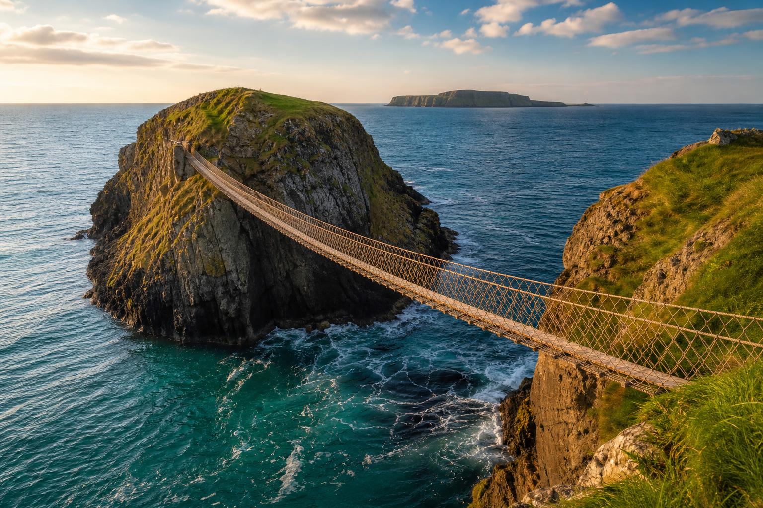
The Carrick-a-Rede rope bridge

A 20-metre rope-and-plank bridge to a small basalt island, swinging above a 30-metre drop into clear Atlantic water. Walk down the cliff path from the car park (1 km), cross the bridge, walk the island, cross back. National Trust owned and run on a timed-ticket system in season.

Good to know · MUST be pre-booked online — same-day tickets sell out in summer. Closes in high winds. NT members free but still need a ticket. Not suitable for vertigo or very young children.

Town

Ballintoy harbour

A tiny stone harbour at the foot of a steep zigzag road, sheltered by sea stacks and a chalk cliff. Working fishing boats, a small café in season, and the path that leads on to White Park Bay. The Iron Islands of Game of Thrones — but the place sells itself without it.

Good to know · Free. Drive down the steep harbour road carefully — single lane, blind bends. Limited parking at the bottom; overflow on the road above.

Beach

White Park Bay

A two-mile crescent of white sand between two headlands, owned by the National Trust. Cattle wander down to the dunes. Almost always empty even when Carrick-a-Rede is fully booked. Walk in from the small NT car park on the A2, or along the coast from Ballintoy.

Good to know · Free. Small NT car park signposted from the A2 — limited spaces. Steep path through the dunes; not buggy-friendly. No lifeguards.

History

Kinbane Head & Castle

A 16th-century McDonnell castle on a long thin chalk headland, three miles west toward Ballycastle. Almost no one stops. The path down is steep but the headland walk is one of the great quiet moments on this coast — Rathlin Island floating offshore.

Good to know · Free. Small clifftop car park signposted off the A2. Steep stone steps down — care in wet weather.

History

Ballintoy Church

A whitewashed Church of Ireland building on the hill above the harbour, dating from the 1810s on much older foundations. Walk the few hundred metres up from the harbour for the view back down — boat, harbour, sea stacks, all framed.

Good to know · Free. Open during services and most summer afternoons. Park at the harbour and walk up.

Local businesses

Places we'd point a friend to.

Hand-picked, not paid for. The ferries, the beds, the pubs and the bike hire that make a visit work.

Before you go. These listings are compiled from public sources and aren't yet verified by the businesses themselves. Hours, menus and prices change with the seasons — always check directly with the venue before travelling, and book ahead in July and August. Owners can get in touch to update their listing.

Eat

Do

Run a place in Carrick-a-Rede & Ballintoy?

Our directory is curated, not pay-to-play. If we'd recommend you, you can be on here.

See how to get listed

Got a window or a counter?

Download a free A5 QR card for Carrick-a-Rede & Ballintoy — print it, stick it up, and visitors land straight on the Carrick-a-Rede & Ballintoy guide.

Ask a local

The bits that aren't on Google.

Common questions

What people ask about Carrick-a-Rede & Ballintoy.

Is the Carrick-a-Rede rope bridge worth it?

Yes if you don't mind a 30 m drop on a 20 m rope-and-plank bridge. The bridge connects the mainland to the tiny island of Carrickarede, originally built by salmon fishermen. The crossing itself takes seconds, but the cliff walk along the way and the views back to Rathlin and Scotland are the real reward.

Do you need to book Carrick-a-Rede in advance?

Yes — the National Trust uses timed-entry tickets and the bridge sells out in summer. Book online before you arrive; walk-up tickets are not guaranteed. The car park is at the visitor centre; from there it's a 1.2 km clifftop walk each way to the bridge itself.

How long does the Carrick-a-Rede visit take?

Allow 1.5 to 2 hours from car park to bridge and back, including time at the island. The walk is on a good path but involves significant ups and downs and steep steps; not suitable if you have mobility issues or a strong fear of heights.

What else is there to see near Carrick-a-Rede?

Ballintoy Harbour (a Game of Thrones filming location for the Iron Islands) is 2 minutes away, with a tiny working harbour and a sea-stack-strewn cove. Whitepark Bay, a stunning 5 km curve of sand, is 5 minutes west. Combine all three plus the Giant's Causeway 15 minutes further on for a strong day on the coast.

Practical

The things you'll wish you'd known.

Fuel
Bushmills (15 min west) or Ballycastle (10 min east). Nothing at the harbour itself.
Cash
ATM in Bushmills or Ballycastle. NT site takes card; harbour café in summer takes both.
Currency
Pound sterling (£).
Parking
Carrick-a-Rede NT car park is paid; pre-book the bridge ticket and parking is included. Ballintoy harbour parking is free but tight.
Phone signal
Patchy down at the harbour; better up on the cliff.
On the route
On the Causeway Coastal Route between the Causeway and Ballycastle. Bushmills 15 min west; Ballycastle 10 min east.

Designed & developed by ideapath.app