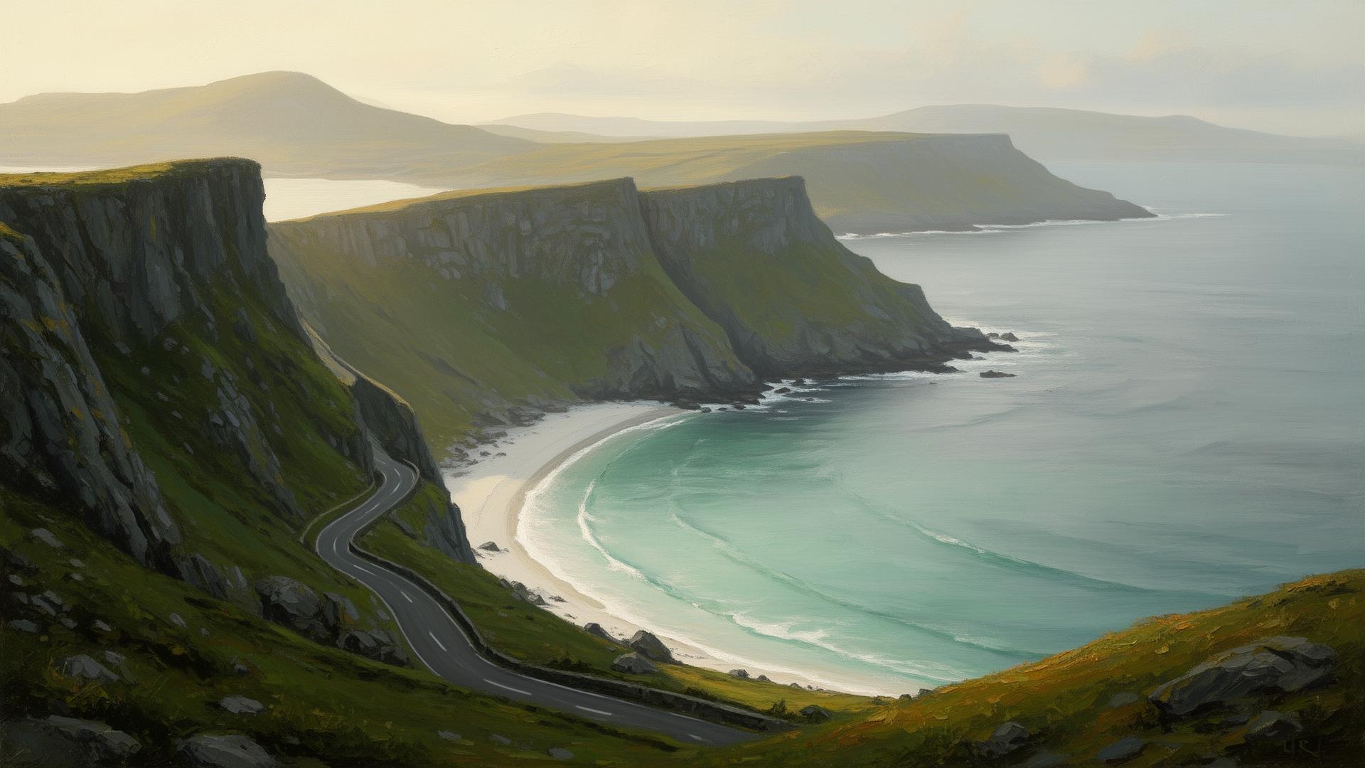
The Atlantic Companion · Wild Atlantic Way · Mayo

Welcome to Achill Island.
We're glad you're here.

Achill — Acaill, Oileán Acla — is the largest of Ireland's islands, joined to the mainland by a road bridge at Achill Sound. 36,500 acres of bog, mountain and Atlantic cliff, dominated by Slievemore (672m) and Croaghaun (688m), whose sea cliffs are among the highest in Ireland and Europe. Keem Bay is the postcard — a Blue Flag horseshoe of white sand under a steep approach road. The Slievemore deserted village, abandoned during the Famine, is the elegy. The Wild Atlantic Drive loops the southern half of the island and is one of the WAW's signature routes.

Keem Bay, the Atlantic Drive, the deserted village at Slievemore.

Sharing from the Wild Atlantic Way

You're in Achill Island. Send it to someone who'd love it.

First things first

Where are you headed next?

Tell us once and we'll shape the rest of the page around it.

The essentials

What you shouldn't miss.

Locally chosen, not algorithmic. In rough order of "if you only do one thing".

Beach

Keem Bay

A Blue Flag horseshoe at the western end of the island, accessed by a steep cliffside road that tour buses can't take. Basking sharks return each summer to feed in the bay; Heinrich Böll wrote about Keem in his Irish Journal. The cliff approach itself is part of the experience.

Good to know · Free parking above the bay; the road down is single-track. Lifeguards in summer. No facilities — bring water.

History

Slievemore Deserted Village

Around a hundred ruined stone houses on the southern slope of Slievemore mountain, abandoned during and after the Great Famine. A 'booley' settlement — used seasonally for summer grazing — that became permanent and then was emptied. Walk the stone street; the silence is the point.

Good to know · Free, always open. Park at the bottom of the hill near the cemetery. Sturdy shoes, exposed terrain.

Drive

Wild Atlantic Drive

A 40km loop around the southern coast — Achill Sound, Cloghmore, the Atlantic cliffs above Ashleam Bay, Keel and Dooagh. The cliffside section between Cloghmore and Dooega is the most dramatic — a single-track road on a narrow shelf with a 300m drop to the sea on one side.

Good to know · Drive clockwise from Achill Sound. Narrow road, no campervans on the cliff section. Allow 90 minutes plus stops.

View

Croaghaun Cliffs

Croaghaun mountain rises 688m straight from the Atlantic at the western tip of Achill — its sea cliffs are among the highest in Ireland and rank among the tallest in Europe. Visible only from the sea or from a stiff hill walk above Keem Bay. The Coastguard Hut walk from Keem gets you the closest land view.

Good to know · Walk from Keem Bay car park, signposted. Allow 2 hours return. Steep, exposed — clear weather only.

Beach

Keel and Trawmore Strand

The main village on the island's south coast, with a 5km Blue Flag strand running west towards the dramatic cliffs at Minaun. Surfing town — Achill Surf School operates here. The cliffs of Minaun (466m, the Cathedral Rocks below) rise straight from the western end of the beach.

Good to know · Free parking at the strand. Lifeguards in summer. Surf hire in the village.

History

Kildownet — Grace O'Malley's tower house

A 15th-century tower house on the southern shore at Kildownet, used by the pirate queen Grace O'Malley (Gráinne Mhaol) in the 16th century. The 1894 Clew Bay drowning disaster victims are buried in the small cemetery alongside — 32 people, mostly young women, drowned when their hooker capsized.

Good to know · Free, signposted from the Atlantic Drive. Always open. Small parking area.

Local businesses

Places we'd point a friend to.

Hand-picked, not paid for. The ferries, the beds, the pubs and the bike hire that make a visit work.

Before you go. These listings are compiled from public sources and aren't yet verified by the businesses themselves. Hours, menus and prices change with the seasons — always check directly with the venue before travelling, and book ahead in July and August. Owners can get in touch to update their listing.

Eat

Drink

Stay

Run a place in Achill Island?

Our directory is curated, not pay-to-play. If we'd recommend you, you can be on here.

See how to get listed

Got a window or a counter?

Download a free A5 QR card for Achill Island — print it, stick it up, and visitors land straight on the Achill Island guide.

Ask a local

The bits that aren't on Google.

Common questions

What people ask about Achill Island.

Is Achill Island worth visiting?

Yes — Achill is the largest island off Ireland, connected to the mainland by a road bridge so no ferry is needed. It has five Blue Flag beaches (Keem, Keel, Dugort, Golden Strand, Silver Strand), the dramatic Atlantic Drive around the south of the island, the deserted village at Slievemore, and some of the best sea cliffs and surf in Mayo.

Do you need a ferry to get to Achill?

No — Achill is connected to the mainland at Achill Sound by a swing bridge, so you simply drive across. Keep going west on the R319 for the island proper. The ferries you may have read about run further out to Clare Island and Inishturk, not to Achill itself.

What is Keem Bay famous for?

Keem Bay is the often-photographed horseshoe beach at the far western end of Achill, reached by a narrow cliff-edge road. It's known for turquoise water, basking sharks in early summer, and the ruins of Captain Boycott's house above the bay. Parking is tight in July and August — go early or late.

How long do you need on Achill Island?

One full day covers Keem, Keel, the Deserted Village and the Atlantic Drive. Two nights lets you walk the Minaun Cliffs, surf at Keel, take in a sunset at Dugort, and not feel rushed. Achill rewards slow time — half-day visits never quite do it justice.

Practical

The things you'll wish you'd known.

Fuel
Achill Sound and Keel. Fill up in Mulranny if you're low — long stretches between.
Cash
Achill Sound. Some pubs cash-only on the island.
Pharmacy
Achill Sound. Castlebar mainland for anything urgent.
Parking
Free at Keem (above the bay), Keel, Slievemore, Kildownet, Atlantic Drive viewpoints.
Phone signal
Patchy on the western half — Keem and Croaghaun area especially. Download maps.
Weather
Big Atlantic island. Driving conditions on the Atlantic Drive change fast — don't push it in low cloud.

Designed & developed by ideapath.app